 |
 |
|
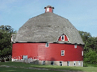
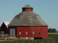
Overview: This project is designed to bring the use of GIS and GPS to the schools in Illinois. Since these are new topics for most students, we are trying to develop a project all students can participate at any grade level in Illinois schools. In this project, students will learn how to collect data and information using certain criteria. The criteria can be modified to any type of state project as well. We selected round barns since they are found across most of the state. There are 102 counties in Illinois and it has been reported that round barns can be found in over seventy of the counties or maybe in all 102. The idea of the project is two fold. The first one is to map the barns locally for schools or school districts using GIS and GPS. This could be accomplished on a county map using TIGER data and either ArcView or ArcVoyager. The second one is to use the Internet to bring the results together on one map of Illinois at a web site that all schools across Illinois can explore. The main goal of this project is to see if there is a pattern to the location of round barns. If there is a pattern, the next step is to explain what might have caused this pattern. If you are interested, please email us. We are not sure when it will start. Also if you want to learn more about the project, go to ArcLessons at ESRI and download the whole lesson. |
|
Return to
Main Page
|