|
What
is GIS?
|
|
|
|
What
is GIS?
|
|
It is a Geographic Information System
GIS is a computer system for capturing, storing, checking, integrating, manipulating, analyzing and displaying data related to positions on the Earth's surface. Usually, a GIS system is used for handling maps of one kind or another. These might be represented as several different layers where each layer holds data about a particular kind of feature (land forms, roads, demographics and features). Each feature is linked to a position on the graphical image of a map.
Layers of data are organized to be studied and to perform statistical analysis (i.e. a layer of customer locations could include fields for Name, Address, Contact, Number, Area). Uses are primarily government related, town planning, local authority and public utility management, environmental, resource management, engineering, business, marketing, and distribution.GIS technology can be used for scientific investigations, resource management, and development planning. For example, a GIS might allow emergency planners to easily calculate emergency response times in the event of a natural disaster, or a GIS might be used to find wetlands that need protection from pollution. Schools can use it to develop a "Community Atlas" or look at problems like bus routes and local environmental issues.
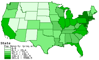
The map below was obtained from the "Tiger Map Server" and represents the
Total Population Density by State of the United States
Return to the Main GIS page